Saturday, June 11, 2016

Montrose, June 9th and 10th, 2016: Epilogue

Well it seems that my choice of route home was validated by all but one element, the town of Escalante.  It is not a one horse town, more like a one jackass town that ran away years ago.  The motels are old but utilitarian, not beginning to approach quaint.  The desk clerk was not at all receptive to my attempts at humorous repartee.  There was one operating restaurant offering a surprisingly high-board bill of fare.  It had drawn, or perhaps coerced a rather large patronage this evening as it was the only game in town.  One of the waitresses approached and asked me where I would like to sit and in my usual self-effacing manner indicated that any table she wished to assign me would be satisfactory.  This seemed to throw a well-forged monkey wrench into her mode of operation.

Once seated and presented with a menu she assured me she would return for my drink order tut suite.  Fifteen minutes later, and ten minutes too many, I retreated from the establishment flashing a look of disdain at my waitress as I made for the door.  She seemed taken by surprise, but there is one thing I will not tolerate, and that is being ignored when I have cash in pocket.  There are more than a few exotic dancers that will affirm my assertion.  Sometimes, sadly, my sense of indignation at maltreatment leaves me with few and much inferior choices.  I dined on Trisciut Crackers and Pepsi in the bump in the road known as Escalante.  And I doubt that the waitress who spurned me will have remembered by shift’s end.  So much for righteous indignation.

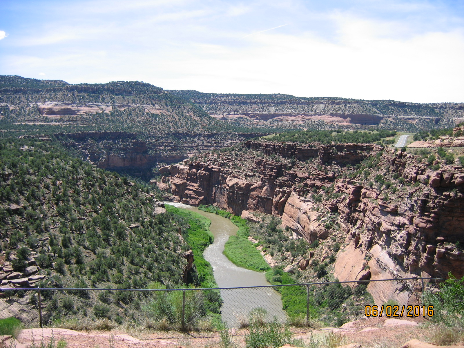
 As I was still in the Grand Staircase-Escalante complex, the views remained among the most intriguing one can encounter in the American West.  This is cowboy country, plain and simple.  An aside about Escalante.  You may be wondering why they named this region for a Cadillac.  No, the region is named for the aforementioned river (see yesterday).  The river was not named for a Cadillac either, but for Silvestre Velez de Escalante, a Franciscan priest who, along with Father Atanasio Dominguez and cartographer Bernardo Miera y Pacheco and eight others from Santa Fe (capital of Nuevo Mexico) conducted an expedition to establish and overland route to Monterey, Norte California in 1776 (Who can tell me what other important historical event occurred in 1776?).  They failed to achieve their goal but did, in their attempt, leave an invaluable legacy in maps of the Utah Valley (present day State of Utah). If you don’t understand the connection to Cadillac, perhaps your sense of humor is too high-brow for my humble offerings.

I ate breakfast at a quaint restaurant in Tropic, Utah.  There was no chance I was going to give the Escalante dining establishment another chance.  I can really hold on to a grudge; there are more than a few exotic dancers that will affirm my assertion.  From Tropic it is a short sprint past the entrance to Bryce Canyon National Park (that’s number two, I’ve been there several times so opted not to take the side trip... but from the highway one can see the features that make this a destination) to highway US-89, which is to Western scenic travel what Route (US) 66 is to kitsch nostalgia travel.  If you visit the five Utah National Parks (have you named them all, yet) you will spend a considerable number of miles on US-89.  My route home took me through Zion National Park which is the shortest if hardly the fastest way home.  But the vistas are without parallel, in fact I don’t think there is a straight stretch of road in the park (That’s a geometry joke, son!).  The road in too narrow and the park too crowded for stop and shoot photography so the following picture was stolen from Google Images. Be prepared, Zion is a way-through park, and they charge you $30 per vehicle just to use the highway.


The route from Zion takes us post haste back to I-15 in the vicinity of St. George (day one) and a turn toward home.  It was early in the afternoon when I neared St. George so opted to proceed onto Las Vegas for the night so as to minimize the hours and miles on the last day of my trip.  I am a strict adherent to the admonishment, “What happens in Vegas stays in Vegas” but I am pleased to share there are no criminal charges pending. Like Hillary, I’m hoping to ride it out until after the election!


The hop to home was as boring as ever so I ratcheted up the excitement for my fellow drivers by sticking to the speed limit in the passing lane.  Yeah, that was me!

Wednesday, June 8, 2016

Montrose, June 8, 2016

What a view!

Well I am sure you are all relieved to read that I have completed the first leg of the homeward journey.  I know what you are thinking, “Thank God I won’t have to read any more of these travel blogs; my eyes are developing callouses!”  Well don’t get to comfortable because I traveled a far piece today and took lots of pictures.
 
But before we get into the substance, let me lay a little groundwork.  For the last few days in Montrose, I was spending a good deal of time looking at the map and wondering if my original plan for the return trip might be rerouted in the name of exploration.  Originally, my plan was to traverse the San Juan mountains to the south via US-550 trough Ouray, Silverton and Durango, better known as suicide alley.  It is a beautifully scenic drive but it is, as I have noted before, a bit of a white knuckler.  Cowardice however, was not the cause for my pause.  This route would have taken me to Cortez (been there) then southward through New Mexico to Gallup and the I-40 westbound to Flagstaff.  I have nothing against this shadow of Route 66, but I have traversed the real estate so many times the Tumbleweeds wave to me as I whiz by.  So I decided on another route.

I left Montrose fully fed at 0730 hrs and headed north to Delta on US-50 until it joined I-70 in Grand Junction, CO.  The direction of travel took me west past the Colorado National Monument (a must see by the way, especially if you like western landscapes) and into Utah.  Continuing this direction to I-15 takes one through the San Rafael Swell (a geologic feature, not a glandular malfunction) and its haunting starkness.  But I have done that a couple of times in the past decade as well. I decided to take the longest, slowest path I could find: UT-24 which runs between the San Rafael Reef and the San Rafael Desert.  If you are skittish about traveling alone on secondary highways that offer no services (for well over one hundred miles), this would not appeal to you.  It is barren, desolate country.  The geological features appear as they might have been sculpted by ancient aliens (eh, Quicksand?) and break into a tribal war dance, but are just a warmup for what’s coming.


Henry Mtn


Ancient Aliens?


At Hanksville, not much of a town, the highway bends a bit more westerly and after forty miles or so enters Capitol Reef National Park (Utah boasts five National Parks.  Can you name the other four?).  What can I say about the park?  I think I’ll let the pictures speak for themselves.


Capitol Reef

Capitol Reef
Capitol Reef
Capitol Reef

The road through Capitol Reef leads to the town of Tobey, where I taught the local deli operator how to make a proper pastrami sandwich (On rye, provolone cheese, 1000 island dressing, coleslaw. She charged me sixty-six cents for a side of coleslaw.)  After my repast, I troubled the owner for directions out of town. I suppose his look of derision was because there was only one intersection and I had missed it coming in.  Never the less, I successfully navigated myself out of town on UT-12 which lifted me out of the desert and into the Dixie National Forest.  This also, as it turns out, is a rather impressive drive.  There is quite a bit of elevation gain with the summit at 9,900 ft.  The highway then gives up its heights rather rapidly and dumps us into the coup de grace, the Grand Staircase-Escalante National Monument. (No, a National Monument is not a National Park so it is not part of the answer to the question above. No, I do not know the difference between a National Monument and a National Park… what do I look like to you, a ranger?)

Dixie Natl Forrest

Dixie Nat'l Forest


I had been through parts of the Monument before it was a monument.  It is an other-worldly environment.  I will let the pictures tell the story.  But the driving experience must be described:  for the first part of trek, the road is atop a sort of plateau looking down into a confusion of canyons created by the relentless flow of the Escalante River. The Escalante River eventually joins the Colorado in Glen Canyon (Lake Powell). Some sections of the roadway are just barely wide enough for two full lanes with no shoulders and severe drops of hundreds of feet for both directions of travel.  Eventually the road winds down the grade and into the canyon.  There are plenty of picture taking opportunities if your trigger finger doesn’t give out.  I ran out of film.  Wait minute, I have a digital camera!


Escalante

Escalante
Escalante
Escalante

Escalante

The travel day ended in the town of Escalante.  So far, I’ve not seen much to impress me here.  I will relay anything of interest if such should occur.

Friday, June 3, 2016

Montrose, May 31, 2016

Montrose, May 31, 2016

Thinking you might be getting bored in my absence, I decided to go a wandering in hopes of discovering something that would amaze you.  You’re welcome.

Since arriving in Colorado, I have been inundated with recommendations for places to go and things to see.  One of the conundrums associated with traveling in this state is the ubiquitous tors.  I have travelled extensively on the highways and byways of the American southwest and while there are myriad roads beckoning the automotive adventurer within each of the states, it seems none have outdone the ambitious Coloradoans in their effort to build a pass over ever mountain range, a route through every river valley (and I haven’t even been tempted to leave the pavement yet).

A case in point is Colorado state route 133 (CO-133) which crosses the ridge in the vicinity of the Maroon Belles-Snowmass Wilderness at McClure Pass (8,755 ft. elev.) and drops down rapidly into the Crystal River Valley and the quaint town of Redstone.

The route starts at Delta, an agricultural center in the shadow of Grand Mesa (you know it when you see it, and yes it is grand, really grand… but I digress).  A trip down the central thoroughfare brings on a wave of nostalgia that we are really too young to experience.  Main Street is old US-50 (a frequent byway in our travels), no freeway bypass here. US-50 turns west out of town and our route (CO-92) steers ENE.  Once you are through the town its basically fruit orchards and alfalfa fields with the aforementioned mountain ranges as background.  The next town of note is Hotchkiss and a switch to CO-133 where you join the Gunnison River.  The landscape offers so many opportunities for photographs it is easy to get hypnotized into pulling off at any wide spot and start snapping away.  And as this is a visual medium, I will let you decide.


The road is not at all challenging until you reach the crest at McClure Pass, then the highway descends a steep wet of switchbacks, but still not too challenging, into the valley where we encounter Redstone, the cliff walls that give it its moniker and the lodge therein.  We arrived at about 1400 hrs and were the only patrons in the grill. The food was excellent, although as the experienced nomad would anticipate, resort priced.  But then, when breathing rarified air, a twelve-dollar cheeseburger is not quite as offensive.


Redstone Coke Ovens


Although CO-133 continues north, it eventually tees into I-70 which is all freeway; not suitable for earning your “I’m not lost, just a little confused.” merit badge.  So we opted to retrace our route over McClure Pass to the junction with 12 RD (no, I don’t understand the road-naming protocol either) and turn our voyage in the direction of Crested Butte.  Unfortunately, about one hundred yards after the turn, we encountered one of those generator-powered, portable, traffic-advisory trailers that informed us Kebler Pass was closed (no, I don’t know if there are cookie-baking elves living there).  That put the kibosh to any further exploration that day so back to Montrose we went.

Montrose, June 2, 2016

Yes, I was remiss in getting May 31 all polished up and posted before we took to the road again on June 2.  This outing targeted a man-made object of curiosity, The Gateway Auto Museum, in Gateway, Colorado.  Gateway isn’t a town per se but an area defined by the confluence of West Creek and the Dolores River (yes, the same Dolores… even more mobile than we previously credited her as she was active all the way up to Mesa County… tramp) in BLM land west of the Uncompahgre National Forest.  It was at this junction that John Hendricks, founder of The Discovery Network, decided to build a retreat resort and automobile museum. No, I do not know what one has to do with the other: Rich people, sheesh!

The museum is very nice and concentrates its collection on American cars from the early 1920s to the 1970s with cultural commentary as one would expect in such a museum.  But, not surprisingly, the star attraction of the trip is the geography.

The route begins with US-50 from Montrose to Whitewater where we transition to CO-141, cross the ever-present Gunnison River and enter Unaweep Canyon.  If you ever attempt this tour, note that the signage for the left turn onto CO-141 is scant and gives little warning that a left turn is at hand.  When you get to the Utah border (about 40 miles), you’ll know you missed it (I nailed it!).  And when they say canyon, they mean C-A-N-Y-O-N!  This is a spectacular drive with red walls rising vertically on both sides of the meadowland through which the road curves back and forth.  There are even a couple of waterfalls cascading down the north wall which you can photograph from wide spots in the road.  The terrain, geology and vegetation are more Utah than Colorado.  At this time of the year the meadow grass on the canyon floor and pinyon pine on the canyon walls are at their verdant best making for a picture post card contrast with the red cliffs.  It would be enough to make the cliffs at Redstone (no, you just read about it in the May 31 trip above… pay attention) blush.  That’s a joke… Redstone… blush. Aw, c’mon!


This drive is one of the best I have taken, and we’re only half-way through the day.  At any rate, John Hendricks decided to build a resort here and house his collection of classic American Iron.  They have everything from Model “T”s to a 1970 Chevy Malibu SS and a Chord to boot.  There is a 1956 Buick Special convertible that is original; no restoration.  The museum and restaurants are open to the public but access to the residence areas is pretty tightly controlled.  Probably to keep me out.


We ate lunch in the Paradox (the name’s a mystery to me… God I’m funny!) Grill.  I know it seems contrary to the nature of an accountant, but I had to try the nine-dollar homemade tortilla chips listed on the appetizer menu.  What could possibly justify nine-dollar chips?  It turns out they are served with freshly made guacamole and red and green hot sauce.  Would I pay that much for chips in San Diego?  No.  But this place is remote and they have to get their produce from Grand Junction, I imagine.  My sandwich was a combination of black forest ham and pulled pork.  Oh, yeah?  Well think again, it was excellent.


After lunch and maybe an hour in the museum we headed out to the southeast on CO-141 alongside, you guessed it the Delores River.  We traced the river through a series of deep canyons and when available, a look down a side canyon made us appreciate that we were in a maze of canyons that would be impossible to navigate without the aid of the Colorado Dept. of Highways and the effort they had expended to build this highway.  The road is so convoluted the trip takes about three hours while the road in was about one and three-quarters of an hour.

The Dolores River eventually combines with a confusion of smaller water tracks at Shamrock Mines and emerges as the San Miguel River.  The highway continues as it gently elevates to bring itself out of the canyons and onto a mesa.  Once through the farming and uranium mining area of Naturita, we transitioned from CO-141 to CO-145 and continued on to Placerville (yes, California has one too).  There we transitioned onto CO-62 which took us through some impressive pasture land and into Ridgeway (remember True Grit?) which put us on US-550 to Montrose.

One more thing:  Just outside of Ridgeway (north) is a park dedicated to local resident and television personality, Dennis Weaver (look it up, Tumbleweed).  We were coerced into stopping to view a twenty-two-foot-tall eagle statue commissioned by his wife.  The theme of the park is very spiritual.  I stated it should have been a statue of a carrot.  He was a vegetarian.  Yeah, my traveling companions didn’t think it was funny either.


Thursday, May 26, 2016

Montrose, May 25, 2016

I know what you’re thinking: “Dale, why the desert?  Why does it always have to be the desert?  Don’t you ever go anyplace else?  It’s all rocks and lizards, arroyos and tumbleweeds.  What’s the deal, didn’t your mother breast feed you as an infant?”

Well the answer to the last question is: I don’t remember.  But it doesn’t always have to be the desert.  I can deal with another geoclimatological zone (hooray, I made up another word).  I’ll show you that I can be flexible; starting right now.

Wednesday morning it was up, shower and out the door by 0800 hrs (that’s eight o’clock in the morning for you civilian types).  A quick stop for gas and then about ten minutes of driving around Cortez looking for my highway (yes, I got lost again!) out of town.  It was about a block away from my motel, but in the opposite direction from the gas station.

I chose to take CO-145 on this, the last leg of my outward journey.  It is one of two routes to Montrose. The other, US-550, is quite the white knuckler, but more about that on the return trip (this is known as a tease in the advertising game), CO-145 might as well be named the Dolores Highway as it runs through Dolores County, through the town of Dolores, along the Dolores River.  Local lore is that this Dolores chick really got around.


If you ever wondered where San Diego's water comes from, well it starts right up there.


The drive needs little descriptive language as the photographs below serve well to tell the story.  This (compared to say, US-550) is an easy drive for an old hand and not so terribly challenging that a less experienced mountain driver wouldn’t be able to negotiate it.  It has some significant elevation changes but the road is in good repair with no intimidating no-shoulder drop-offs to the side, hairpin turns or switchbacks.  And this is important because you will want to be able to take in the scenery as it goes by.


GPS Elevation at Lizard Head Pass

The elevation reaches over 10,000 feet at its apex.  At ten o’clock in the morning (that’s 1000 hrs to you mil types) the temperature at Lizard Head Pass was 47o F… I was wearing cargo shorts and a polo shirt, in case you noticed the camera shake.  The highway runs through the town of Rico (shown below), past the side route to Telluride and into Placerville where I turned north onto CO-62.  It is a short drive to reach Ridgeway, the town where the John Wayne version of True Grit was filmed.  A funny aside:  When I was a teenager and saw the movie True Grit, I noted to myself and anyone who would listen, “I’ve been to Oklahoma (the setting for the story), and that is not Oklahoma.” You can’t get many passed me.

Rico, CO


Rico graveyard, right by the side of the highway


The next turn is onto US-550 which has been drained of its venom by this time.  It is a leisurely drive through the farmland of Montrose County into the city itself.   I will not boar you with the tedium of family activities.


I will begin my trip home in a couple of weeks, so stay tuned.  If anything of note happens in the meantime (and if you really knew me well you would know how high the probability runs), I will write you from jail. 

Tuesday, May 24, 2016

May 24, 2016 Montrose

I left St. George, Utah with little fanfare and no breakfast to charge into Indian Country, i.e., Navajoland.  My first waypoint was Hurricane, Utah.  It has changed significantly since I was last there (circa 1997).  The heretofore two-lane main street is now a five-lane boulevard and the once antiquated storefronts are new and shiny.  The town has expanded to the west with nationally recognized retailers, mostly fast food outlets. Hurricane continues to exist as a jump off point for the National Park recreation offers in the area; Zion, Bryce, Lake Powell, et al.  I am glad to see it is thriving.


From Hurricane, I proceeded along state highways 59 and 389 into Arizona and the little hamlet of Fredonia, Arizona.  I am convinced that Fredonia survives only to sell alcohol to persons of thirst preparing to travel into the National Park rich, but somewhat dry, Utah. I counted one gas station and three liquor stores among the four businesses in the town.  From Fredonia, the road turns north where in a matter of yards, you enter Kanab, Utah where you can buy the non-alcoholic provisions for your expedition. From Kanab, I had two choices to reach the day’s destination, Cortez, Colorado.


This gets confusing if you are not familiar with the area or if you do not have a map in your hand. Both options are numbered US-89.   I am not going to try to explain it verbally.  Let it suffice to say I took the leg that skirts the southern edge of the Escalante-staircase National Monument and it is spectacular.  For my money… well actually, it is fee free on US-89, it is the most impressive non-fee drive I have encountered.  Someday, it will be a destination; stay tuned.


This route eventually meanders to Page, Arizona; launching point for Lake Powell.  The water level in the lake is depressingly low.  Too bad, there are few locales in the world as stunning as Lake Powell from water level.  I got lost in Page.  It’s a lot easier than you think.  But it is a small town and in driving about looking for the road out, I wandered into an old part of town known as the little hotel district.  It’s actually one street lined with utilitarian rental complexes that look as if they were built for workers during the construction of Glen Canyon Dam.  Now they seem to operate as hostels for thrifty world travelers.  What do you think, Tumbleweed?


Finding my way out of Page (it was even odds) I took AZ-98 to the southeast to meet up with US-160 running northeast along the southern extreme of Monument Valley and Kayenta, Arizona.  Again, these are scarcely traveled highways that offer incomparable visuals.  I never tire of the experience.


Eventually the route takes you into more familiar geology and through some really ugly desert as you pass four corners (if you are unfamiliar with this term, look it up) and into Colorado.  Cortez is the first city you encounter; it’s life blood is farming and tourist services for nearby Mesa Verde National Park.  I found the lone surviving Mexican restaurant and enjoyed a cheese enchilada and tamale.  While there were quainter motels, I chose a Travel Lodge:  The photo below explains it all.

San Juan Mountains from Cortez

 
Cortez is a city by definition


Monday, May 23, 2016

May 23, 2016 - Montrose

Well here I am tearing up the roads of America once again in search of…

I have no idea.  But so long as the objective remains undefined, I will never have to admit I have completed the pursuit.  If that makes perfect sense to you then you are reading the right blog.

This journey targets the city of Montrose, Colorado… eventually.  It is the home of my sole surviving aunt, Barbara Coster (nee Frank).  But I will spare you the family story.  What I do want to share with you is the experience of the road trip.  I am amazed at the number of people I have met who are dumb founded by the notion of packing up the car with no agenda (although this particular trip has the family element), no reservations and no firm return dates.  Some of my acquaintances recoil at the notion of life without room service and spas.  Others express great trepidation being lost in a wilderness of motels with no time-certain check in.

In answer to your query, “But Dale, you must be able to fly to Colorado.” I respond, have you been following the TSA performance stories in the news this week?  I don’t fly, and three-hour security lines are just one of a myriad of reasons.  Here’s another; have you ever been served Mexican cuisine as the (I hear, no longer included) in-flight meal?  And yet another:  On those occasions when I did fly (mostly business trips on someone else’s dime) I insisted on a window seat and I spent the entire flight looking at the earth pass by below, wishing I knew what I was missing down there.  And yes, by the time I arrived at my destination, my neck hurt.  I much prefer to be down there, looking at the country close up.

So this trip required a decision; which route to take.  There are two general options (although many variables present themselves within each), north or south.  On a whim, I decided to take the northern route out this time and the southern route back.  My path will take me north along I-15 to St. George, Utah then east along some interesting secondary highway(s) into Montrose.  Then when I return home, I will proceed south through the San Juan Mountains (Rockies) to Cortez, Colorado where I will redirect westward along trails associated with the Mother Road (Route 66) and home.

I know some of you think as I-15 is merely a dedicated express way to Las Vegas.  And for those travelers, it is all yours south of Fremont street.  But once you get past Vegas, one has the chance to encounter some interesting geographical and cultural treasures.  Just north of the Las Vegas metropolitan complex is a Nevada state park that borders lake Meade; Valley of Fire State Park.  As you may have guessed from the name, it is comprised red rocks.  If you didn’t, well, read a book… about anything.  I did not stop to visit on this excursion, but for those of you who might travel to Sin City in the future, schedule some time for a car trip to this remarkable landscape.  I offer you a google image as enticement.  It may just wet your whistle for a road trip, ‘cause there’s stuff like this all over the West.


Valley of Fire
Valley of Fire


About an hour north of Vegas is the last chance to gamble in a little town named Mesquite.  It is situated in the lower Virgin River Valley and I believe serves the non-LDS Utah residents who just can’t handle the trek into Lost Wages.  As the I-15 continues north it cuts across a small but impressive corner of Arizona known as The Virgin River Gorge.  The highway cuts right through this maze of geological wonder and it will take all your better judgment to keep from parking in the traffic lane to take pictures.  There is no shoulder, don’t try it.  The pictures I include here I got from Google images.

Virgin River Gorge


When the road reaches the top of the gorge you spill out into Utah.  The coral hued mesas are among the most dramatic to be seen in the West.  Ten minutes farther and you encounter the city of St. George, nestled in these same mesas.  When I travel alone (which I am on this occasion) I try to find quaint little motels from yesteryear that evoke memories of family trips of my youth.  Tonight I will be a guest of the Dixie Palm Motel.  They boast seventeen rooms, numbered 201 through 217.  The clerk does not know why and stopped looking for the second floor stairs some time ago.  The motel map in printed on a 3 x 21/2 inch piece of paper on which there is an admonishment to drop the room key in the box outside the office when one leaves, so the maids will know you are done.  Yes, the important part of that sentence is that they have keys, real brass keys.  If you don’t understand, you picked the wrong book, try again.


St. George, Utah

St. George, Utah
Dixie Palms Motel


Well, that’s it for today.  I’ll see what comes up tomorrow.